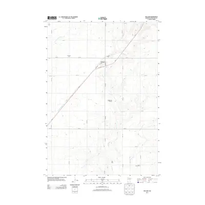
2013 Map of Holland
USGS Topo · Published 2013About this map
The small prairie settlement of Holland centers this Pipestone County landscape, positioned along the diagonal corridor of MN-23 and Old Hi-Way 23. The township is defined by its agricultural layout, with large properties like Brinkmeyer Farms and the Rock River Ranch integrated into the section-line road grid. The geography is shaped by the Coteau des Prairies plateau, where several watercourses emerge, including the Rock River, East Br Rock River, and North Br Pipestone Cr. This map is particularly valuable for genealogists, as it locates several rural burial grounds, including Holland Cem, Saint Martins Cem, and the more remote Luctor Cem in the northwest corner, providing precise coordinates for local family history research.
Find a feature on this map
29 named features on this map. Tap any name to fly to it.
Don’t see what you’re looking for? This feature index may not catch every label — zoom into the map to look around manually.
Map Details
Editions of this 2013 Holland Map
This is the sole edition of this map. No revisions or reprints were ever made.
Other maps of this area

1953 · Watertown
USGS Topo · 1:250,000

1955 · Sioux Falls
USGS Topo · 1:250,000

1958 · Sioux Falls
USGS Topo · 1:250,000

1958 · Watertown
USGS Topo · 1:250,000

1967 · Pipestone North
USGS Topo · 1:24,000

1967 · Edgerton North
USGS Topo · 1:24,000

1967 · Edgerton NE
USGS Topo · 1:24,000
1967 · Ruthton
USGS Topo · 1:24,000

1967 · Ruthton NW
USGS Topo · 1:24,000
1967 · Woodstock
USGS Topo · 1:24,000