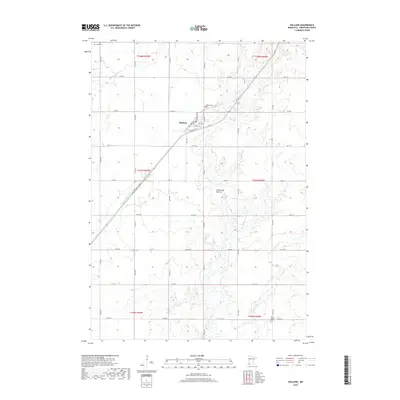
2019 Map of Holland
USGS Topo · Published 2019About this map
The town of Holland serves as the central hub of this Pipestone County landscape, situated where the grid of rural roads meets the elevated terrain of the Coteau des Prairies. This geographic feature, an expansive upland plateau, significantly influences the local drainage patterns. Waters move through the Rock River and its tributary, the E Br Rock River, while the N Br Pipestone Cr and the engineered County Ditch Number One manage the surrounding agricultural plains. For those researching local heritage, several historic burial sites are preserved across the sections, including Saint Martins Cem to the south, Holland Cem near the town center, and Luctor Cem in the northwestern corner. The map details the transition from established street names like Washington Ave and Superior Ave W to the long-reaching county roads that define the region's ranching and farming layout.
Find a feature on this map
43 named features on this map. Tap any name to fly to it.
Don’t see what you’re looking for? This feature index may not catch every label — zoom into the map to look around manually.
Map Details
Editions of this 2019 Holland Map
This is the sole edition of this map. No revisions or reprints were ever made.
Other maps of this area

1953 · Watertown
USGS Topo · 1:250,000

1955 · Sioux Falls
USGS Topo · 1:250,000

1958 · Sioux Falls
USGS Topo · 1:250,000

1958 · Watertown
USGS Topo · 1:250,000

1967 · Pipestone North
USGS Topo · 1:24,000

1967 · Edgerton North
USGS Topo · 1:24,000

1967 · Edgerton NE
USGS Topo · 1:24,000
1967 · Ruthton
USGS Topo · 1:24,000

1967 · Ruthton NW
USGS Topo · 1:24,000
1967 · Woodstock
USGS Topo · 1:24,000