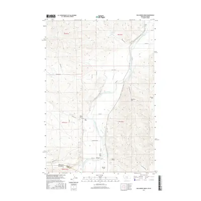
2017 Map of Hollenbeck Draw
USGS Topo · Published 2017About this map
The Clarks Fork Yellowstone River dominates this landscape along the Montana and Wyoming border, serving as the lifeblood for an extensive network of irrigation infrastructure. This 2017 survey details the complex system of gravity-fed water management required for agriculture in this arid region, including the Wills Ditch, Interstate Ditch, Doctor Ditch, and the Grove Cr Canal. The small settlement of Chance sits near the state line, providing a focal point for local history along with the nearby Chance Mountain View Cem and the Belfry Cem located further north. Notable terrain features like Hollenbeck Draw and Big Sand Coulee define the drainage patterns surrounding the river valley. The presence of the historical Meeteetsee Trl suggests long-standing transit corridors through this borderland, connecting the high plains across state boundaries.
Find a feature on this map
47 named features on this map. Tap any name to fly to it.
Don’t see what you’re looking for? This feature index may not catch every label — zoom into the map to look around manually.
Map Details
Editions of this 2017 Hollenbeck Draw Map
This is the sole edition of this map. No revisions or reprints were ever made.
Other maps of this area

1944 · Red Lodge
USGS Topo · 1:62,500

1950 · Clark
USGS Topo · 1:62,500

1954 · Billings
USGS Topo · 1:250,000

1955 · Cody
USGS Topo · 1:250,000

1957 · Billings
USGS Topo · 1:250,000

1958 · Billings
USGS Topo · 1:250,000

1958 · Cody
USGS Topo · 1:250,000

1962 · Cody
USGS Topo · 1:250,000

1966 · Elk Basin NW
USGS Topo · 1:24,000
1969 · Tolman Flat
USGS Topo · 1:24,000