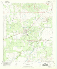
1966 Map of Holliday
USGS Topo · Published 1968About this map
The town of Holliday serves as the focal point for this mid-1960s study of the North Texas plains, where the Fort Worth and Denver railroad cuts a diagonal line through a landscape dominated by the petroleum industry. The region is heavily defined by extensive drilling operations, including the Holliday Oil Field, Gose Oil Field, and Hull-Silk Oil Field, which are crisscrossed by a complex network of pipelines and service roads.
Find a feature on this map
29 named features on this map. Tap any name to fly to it.
Don’t see what you’re looking for? This feature index may not catch every label — zoom into the map to look around manually.
Map Details
Editions of this 1966 Holliday Map
This is the sole edition of this map. No revisions or reprints were ever made.
Other maps of this area

1916 · Iowa Park
USGS Topo · 1:24,000

1916 · Fowlkes
USGS Topo · 1:24,000

1918 · Iowa Park
USGS Topo · 1:31,680

1919 · Fowlkes
USGS Topo · 1:31,680

1931 · Archer City
USGS Topo · 1:62,500

1932 · Dundee
USGS Topo · 1:62,500

1954 · Wichita Falls
USGS Topo · 1:250,000

1956 · Lake Wichita
USGS Topo · 1:24,000

1957 · Wichita Falls West
USGS Topo · 1:24,000

1957 · Wichita Falls West
USGS Topo · 1:62,500