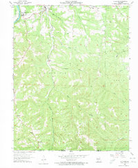
1956 Map of Hollister
USGS Topo · Published 1974About this map
The White River and its reservoir, Lake Taneycomo, carve through this landscape at the northern edge of the Ozarks, where the School of the Ozarks stands overlooking the water near Hollister. The topography is defined by sharp elevation changes and numerous hollows like Big Hollow and Coalpit Hollow, with the Missouri Pacific railroad winding southward along the path of Turkey Creek. This mid-century survey captures a rural landscape transitioning toward modern development while retaining its deep-rooted settlement patterns, evidenced by remote country institutions like Pine Top Sch and Oneness Ch. Local genealogists will find significant value in the documentation of several family-named burial sites, including Vandzant Cem, Horton Cem, and the uniquely named Gobbler Knob Cem.
Find a feature on this map
35 named features on this map. Tap any name to fly to it.
Don’t see what you’re looking for? This feature index may not catch every label — zoom into the map to look around manually.
Map Details
Editions of this 1956 Hollister Map
3 editions found
Other maps of this area

1904 · Harrison
USGS Topo · 1:125,000

1905 · Harrison
USGS Topo · 1:125,000

1907 · Forsyth
USGS Topo · 1:125,000

1945 · Harrison
USGS Topo · 1:250,000

1949 · Harrison
USGS Topo · 1:250,000

1950 · Garber
USGS Topo · 1:24,000

1954 · Harrison
USGS Topo · 1:250,000

1956 · Table Rock Dam
USGS Topo · 1:24,000

1956 · Garber
USGS Topo · 1:24,000
1956 · Mincy
USGS Topo · 1:24,000