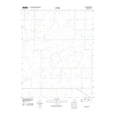
2010 Map of Hollow
USGS Topo · Published 2010About this map
Hollow sits at a crossroads in the southern reaches of this landscape, marking a concentrated point of settlement in an otherwise expansive agricultural and riparian environment. The area is defined by a dendritic network of waterways that flow toward the larger creek systems, including the meandering paths of Big Creek and Big Cabin Creek. The drainage patterns suggest a terrain of gentle relief, where the East Fork Big Creek and Clear Creek carve subtle valleys through the rural countryside.
Find a feature on this map
24 named features on this map. Tap any name to fly to it.
Don’t see what you’re looking for? This feature index may not catch every label — zoom into the map to look around manually.
Map Details
Editions of this 2010 Hollow Map
This is the sole edition of this map. No revisions or reprints were ever made.
Other maps of this area

1886 · Parsons
USGS Topo · 1:125,000

1893 · Parsons
USGS Topo · 1:125,000

1901 · Vinita
USGS Topo · 1:125,000

1913 · Vinita
USGS Topo · 1:125,000

1944 · Oswego
USGS Topo · 1:62,500

1946 · Oswego
USGS Topo · 1:48,000

1946 · Mound Valley
USGS Topo · 1:62,500

1947 · Joplin
USGS Topo · 1:250,000
1948 · Oswego
USGS Topo · 1:62,500
1948 · Mound Valley
USGS Topo · 1:62,500