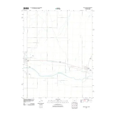
2010 Map of Holly East
USGS Topo · Published 2010About this map
The Arkansas River and the Buffalo Canal define the agricultural and transit landscape of the high plains along the Colorado-Kansas border in 2010. This survey centers on the transition from Holly, Colorado, to the neighboring community of Coolidge, Kansas, showcasing the grid-based irrigation and transportation infrastructure that supports the region's economy. The river's winding course is mirrored by the engineered precision of the canal and a network of arterial roads, including County Road B and County Road JJ. Local history and genealogy interest is anchored by the Holly Cemetery and Coolidge Cemetery, which serve as bookends to the two settlements. Smaller landmarks like the Holly Airport and Holly Dump provide insight into the modern utility and infrastructure of this borderland corridor, where Cheyenne Creek and Spring Creek draw lines across the prairie toward the larger river valley.
Find a feature on this map
31 named features on this map. Tap any name to fly to it.
Don’t see what you’re looking for? This feature index may not catch every label — zoom into the map to look around manually.
Map Details
Editions of this 2010 Holly East Map
This is the sole edition of this map. No revisions or reprints were ever made.
Other maps of this area

1890 · Granada
USGS Topo · 1:125,000

1891 · Albany
USGS Topo · 1:125,000

1892 · Granada
USGS Topo · 1:125,000

1893 · Albany
USGS Topo · 1:125,000

1894 · Granada
USGS Topo · 1:125,000

1900 · Syracuse
USGS Topo · 1:125,000

1920 · Syracuse
USGS Topo · 1:125,000

1953 · Holly West
USGS Topo · 1:24,000

1953 · Holly East
USGS Topo · 1:24,000

1954 · Lamar
USGS Topo · 1:250,000