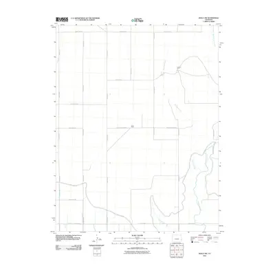
2010 Map of Holly NW
USGS Topo · Published 2010About this map
Cramblet Ranch and Klarna Ranch anchor this portion of Prowers County, where the high plains landscape is defined by a sophisticated system of irrigation and natural drainage. The water management network is remarkably dense, featuring the Amity Canal Rd and specialized watercourses like the Chenoweth Lateral, Dober Lateral, and the evocatively named East Fork Dead Ditch. These man-made features work alongside natural waterways, including the braided paths of Wild Horse Creek and West Horse Creek. A rigid grid of county roads, such as County Road RR and County Road SS, partitions the territory, reflecting the systematic agricultural development of eastern Colorado in the early 21st century. Smaller drainages like Pauls Arroyo and Skeff Creek further detail the local topography, marking the subtle shifts in this expansive ranching country.
Find a feature on this map
25 named features on this map. Tap any name to fly to it.
Don’t see what you’re looking for? This feature index may not catch every label — zoom into the map to look around manually.
Map Details
Editions of this 2010 Holly NW Map
This is the sole edition of this map. No revisions or reprints were ever made.
Other maps of this area

1890 · Granada
USGS Topo · 1:125,000

1892 · Granada
USGS Topo · 1:125,000

1894 · Granada
USGS Topo · 1:125,000

1953 · Holly West
USGS Topo · 1:24,000

1953 · Granada
USGS Topo · 1:24,000

1953 · Holly East
USGS Topo · 1:24,000

1954 · Lamar
USGS Topo · 1:250,000

1955 · Holly NE
USGS Topo · 1:24,000

1955 · Granada NE
USGS Topo · 1:24,000
1955 · Holly NW
USGS Topo · 1:24,000