
1952 Map of Hollyhill
USGS Topo · Published 1954About this map
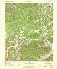
Cumberland National Forest defines the landscape of the McCreary and Whitley county line during the early 1950s, a region where steep topography and natural resources shaped local life. Near the small settlement of Hollyhill, the map records several active coal extraction sites labeled simply as Strip Mine, highlighting the industrial footprint on these timbered hills. The map provides a detailed view of a dispersed rural community connected by small schools and country churches, such as Bear Wallow Sch and New Liberty Ch in the north, and Ryans Creek Ch in the south near Ryans Creek Mountain. The drainage network is dense, with Jellico Creek and Marsh Creek carving deep valleys between prominent landmarks like Granny Holt Knob and Liza Mountain.
Find a feature on this map
56 named features on this map. Tap any name to fly to it.
Don’t see what you’re looking for? This feature index may not catch every label — zoom into the map to look around manually.
Map Details
Editions of this 1952 Hollyhill Map
2 editions found
Other maps of this area

1890 · Williamsburg
USGS Topo · 1:125,000

1894 · Williamsburg
USGS Topo · 1:125,000

1952 · Wofford
USGS Topo · 1:24,000

1952 · Wiborg
USGS Topo · 1:24,000

1952 · Cumberland Falls
USGS Topo · 1:24,000

1952 · Williamsburg
USGS Topo · 1:24,000

1952 · Whitley City
USGS Topo · 1:24,000
1953 · Winfield
USGS Topo · 1:24,000
1953 · Jellico West
USGS Topo · 1:24,000
1953 · Ketchen
USGS Topo · 1:24,000