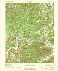
1952 Map of Hollyhill
USGS Topo · Published 1971About this map
Cumberland National Forest dominates this landscape along the border of McCreary and Whitley counties, where high ridges and deep creek hollows define the pattern of rural life in the early 1950s. The settlement at Hollyhill serves as a small hub for the surrounding countryside, connected to dispersed family-named landmarks like Granny Holt Knob and Fate Lee Mtn. The community infrastructure is deeply rooted in local education and faith, evidenced by numerous small institutions such as Bear Wallow Sch, New Liberty Ch, and Kidd Sch. While much of the area remains forested, the emergence of a Strip Mine near Peak Mtn indicates the shifting economic activities of the era. The intricate drainage network of Marsh Creek, Jellico Creek, and Ryans Creek provides the topographical framework for the winding roads and narrow valley settlements that characterize this portion of the Kentucky foothills.
Find a feature on this map
43 named features on this map. Tap any name to fly to it.
Don’t see what you’re looking for? This feature index may not catch every label — zoom into the map to look around manually.
Map Details
Editions of this 1952 Hollyhill Map
2 editions found
Other maps of this area

1890 · Williamsburg
USGS Topo · 1:125,000

1894 · Williamsburg
USGS Topo · 1:125,000

1952 · Wofford
USGS Topo · 1:24,000

1952 · Hollyhill
USGS Topo · 1:24,000

1952 · Wiborg
USGS Topo · 1:24,000

1952 · Cumberland Falls
USGS Topo · 1:24,000

1952 · Williamsburg
USGS Topo · 1:24,000

1952 · Whitley City
USGS Topo · 1:24,000
1953 · Winfield
USGS Topo · 1:24,000
1953 · Jellico West
USGS Topo · 1:24,000