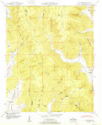
1951 Map of Hollytree
USGS Topo · Published 1951About this map
Bingham Mountain and Sharp Mountain dominate this mid-century survey of the Alabama uplands, where the county line between Madison and Jackson counties traverses the high ridges. The landscape is defined by its karst topography, marked by numerous geological features such as Sharp Sinks, Calloway Sinks, and Keel Sinks. These natural drainage systems are paired with deep hollows and coves that hosted the area's early residents, evident in the network of family-named landmarks.
Find a feature on this map
58 named features on this map. Tap any name to fly to it.
Don’t see what you’re looking for? This feature index may not catch every label — zoom into the map to look around manually.
Map Details
Editions of this 1951 Hollytree Map
2 editions found
Other maps of this area

1888 · Scottsboro
USGS Topo · 1:125,000

1892 · Scottsboro
USGS Topo · 1:125,000

1936 · King Cove
USGS Topo · 1:24,000

1936 · Moontown
USGS Topo · 1:24,000

1936 · Hollytree
USGS Topo · 1:24,000

1936 · Princeton
USGS Topo · 1:24,000

1936 · Lim Rock
USGS Topo · 1:24,000

1936 · Maysville
USGS Topo · 1:24,000
1936 · New Market
USGS Topo · 1:24,000
1936 · Paint Rock
USGS Topo · 1:24,000