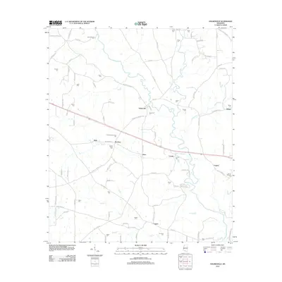
2012 Map of Holmesville
USGS Topo · Published 2012About this map
The Bogue Chitto river meanders through this landscape, defining the topography of eastern Pike County. This area is characterized by a high density of family-named burial grounds, providing a significant resource for genealogists. Notable locations such as the Andrews-Bickam-Quin Cem, Martin-McNabb Cem, and HM Lee Memorial Cem are scattered throughout the rural countryside, often near small established communities like Holmesville, Stella, and Conerly. The road network, including Summit Holmesville Rd and Magnolia Holmesville Rd, connects these settlements across a terrain carved by numerous tributaries like Topisaw Cr and Leatherwood Cr. The map illustrates a contemporary rural Mississippi landscape where modern infrastructure intersects with deep-rooted family landmarks, including the Charles Young Cem and Brumfield Cem.
Find a feature on this map
98 named features on this map. Tap any name to fly to it.
Don’t see what you’re looking for? This feature index may not catch every label — zoom into the map to look around manually.
Map Details
Editions of this 2012 Holmesville Map
This is the sole edition of this map. No revisions or reprints were ever made.
Other maps of this area

1953 · Natchez
USGS Topo · 1:250,000

1956 · Natchez
USGS Topo · 1:250,000

1959 · Natchez
USGS Topo · 1:250,000

1970 · Mesa
USGS Topo · 1:24,000

1970 · Jayess
USGS Topo · 1:24,000
1970 · Tylertown
USGS Topo · 1:24,000
1972 · Osyka
USGS Topo · 1:24,000

1972 · Pricedale
USGS Topo · 1:24,000

1972 · McComb South
USGS Topo · 1:24,000
1972 · Holmesville
USGS Topo · 1:24,000