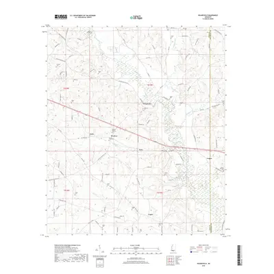
2018 Map of Holmesville
USGS Topo · Published 2018About this map
Holmesville sits as a central point in this landscape where the Bogue Chitto river and its tributaries, such as Topisaw Creek and Leatherwood Cr, carve through the terrain of Pike County. This modern 2018 survey reveals a settlement pattern deeply rooted in family history, evidenced by the high density of small family cemeteries including the Andrews-Bickham-Quin Cem, Charles Young Cem, and Martin-McNabb Cem. Small communities like Stella, Beardens, and Conerly are connected by a network of local roads such as Magnolia Holmesville Rd and Pike 93 Central. The presence of several named crossings, like Bars Br, indicates how the local infrastructure continues to negotiate the winding river system that has defined this region's layout for generations.
Find a feature on this map
97 named features on this map. Tap any name to fly to it.
Don’t see what you’re looking for? This feature index may not catch every label — zoom into the map to look around manually.
Map Details
Editions of this 2018 Holmesville Map
This is the sole edition of this map. No revisions or reprints were ever made.
Other maps of this area

1953 · Natchez
USGS Topo · 1:250,000

1956 · Natchez
USGS Topo · 1:250,000

1959 · Natchez
USGS Topo · 1:250,000

1970 · Mesa
USGS Topo · 1:24,000

1970 · Jayess
USGS Topo · 1:24,000
1970 · Tylertown
USGS Topo · 1:24,000
1972 · Osyka
USGS Topo · 1:24,000

1972 · Pricedale
USGS Topo · 1:24,000

1972 · McComb South
USGS Topo · 1:24,000
1972 · Holmesville
USGS Topo · 1:24,000