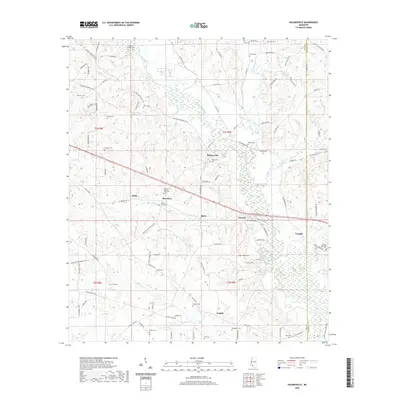
2020 Map of Holmesville
USGS Topo · Published 2020About this map
The Bogue Chitto river system dominates this portion of Pike and Walthall Counties, where small farming communities and historic family burial grounds are scattered across the landscape. The unincorporated community of Holmesville serves as a central landmark, situated near the confluence of Topisaw Creek and the main river. This modern survey reflects a region defined by its rural heritage, where many locations are identified by family names that suggest deep genealogical roots in the area.
Find a feature on this map
102 named features on this map. Tap any name to fly to it.
Don’t see what you’re looking for? This feature index may not catch every label — zoom into the map to look around manually.
Map Details
Editions of this 2020 Holmesville Map
This is the sole edition of this map. No revisions or reprints were ever made.
Other maps of this area

1953 · Natchez
USGS Topo · 1:250,000

1956 · Natchez
USGS Topo · 1:250,000

1959 · Natchez
USGS Topo · 1:250,000

1970 · Mesa
USGS Topo · 1:24,000

1970 · Jayess
USGS Topo · 1:24,000
1970 · Tylertown
USGS Topo · 1:24,000
1972 · Osyka
USGS Topo · 1:24,000

1972 · Pricedale
USGS Topo · 1:24,000

1972 · McComb South
USGS Topo · 1:24,000
1972 · Holmesville
USGS Topo · 1:24,000