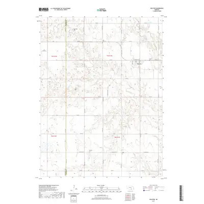
2017 Map of Holstein
USGS Topo · Published 2017About this map
Holstein anchors the northern portion of this landscape, situated along the border of Kearney Co and Adams Co. The area is characterized by a high concentration of burial sites, including Morseville Cem, Logan Cem, Holstein Cem, and West Ward Cem, providing essential points of reference for genealogical researchers. The terrain features notable elevations such as Sugarloaf Hill and Tower Hill, which rise above the drainages of Sand Creek and its southern branch, S Br Sand Creek. To the northeast, Lukow Reservoir and Cottonwood Creek diversify the hydrologic pattern. This 2017 survey reveals a classic rural township-and-range structure, with an extensive network of county roads including Co Rd 62 and Co Rd 64 that intersect the agricultural land and connect the scattered community landmarks.
Find a feature on this map
44 named features on this map. Tap any name to fly to it.
Don’t see what you’re looking for? This feature index may not catch every label — zoom into the map to look around manually.
Map Details
Editions of this 2017 Holstein Map
This is the sole edition of this map. No revisions or reprints were ever made.
Other maps of this area
1894 · Kenesaw
USGS Topo · 1:62,500
1894 · Minden
USGS Topo · 1:62,500
1896 · Wood River
USGS Topo · 1:125,000
1897 · Red Cloud
USGS Topo · 1:125,000
1955 · Grand Island
USGS Topo · 1:250,000
1957 · Grand Island
USGS Topo · 1:250,000
1958 · Grand Island
USGS Topo · 1:250,000
1969 · Upland SE
USGS Topo · 1:24,000
1969 · Holstein
USGS Topo · 1:24,000
1969 · Roseland
USGS Topo · 1:24,000