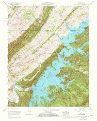
1960 Map of Holston Valley
USGS Topo · Published 1971About this map
South Holston Lake dominates this 1960s landscape, illustrating the profound impact of the South Holston Dam on the regional geography. This survey captures the transition of the South Fork Holston River into a massive reservoir, creating a complex shoreline that borders the Cherokee National Forest and the Kettlefoot Wildlife Management Area. The map reveals a land defined by its prominent ridges, such as The Holston Knobs and Paperville Knobs, which contain numerous small family cemeteries and rural institutions like Bethel Ch and High Point Sch. The presence of Sequoia Camp and Observation Park reflects the mid-century development of the area for public recreation. Genealogists can trace family names through landmarks like Beidleman Cem and Painter Spring, while the intricate network of creeks like Big Jacob Creek and Fishdam Creek shows the original drainage patterns before the waters rose.
Find a feature on this map
54 named features on this map. Tap any name to fly to it.
Don’t see what you’re looking for? This feature index may not catch every label — zoom into the map to look around manually.
Map Details
Editions of this 1960 Holston Valley Map
4 editions found
Other maps of this area

1891 · Roan Mountain
USGS Topo · 1:125,000

1891 · Abingdon
USGS Topo · 1:125,000

1893 · Cranberry
USGS Topo · 1:125,000

1894 · Roan Mountain
USGS Topo · 1:125,000

1894 · Abingdon
USGS Topo · 1:125,000

1895 · Cranberry
USGS Topo · 1:125,000

1897 · Bristol
USGS Topo · 1:125,000

1899 · Cranberry
USGS Topo · 1:125,000

1902 · Bristol
USGS Topo · 1:125,000

1902 · Cranberry
USGS Topo · 1:125,000