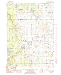
1985 Map of Holton
USGS Topo · Published 1985About this map
Holton serves as a central hub for this portion of the Manistee National Forest, where the western Michigan landscape is defined by the headwaters of Cushman Creek and Cedar Creek. Compiled from 1981 data, this record captures the rural character of the region as it spans the borders of Oceana, Muskegon, and Newaygo counties. Local history is anchored by several long-standing community landmarks, including St Micheals Ch in the settlement of Brunswick and the quiet grounds of Holton Cem.
Find a feature on this map
44 named features on this map. Tap any name to fly to it.
Don’t see what you’re looking for? This feature index may not catch every label — zoom into the map to look around manually.
Map Details
Editions of this 1985 Holton Map
This is the sole edition of this map. No revisions or reprints were ever made.
Other maps of this area

1931 · Walkerville SW
USGS Topo · 1:31,680

1931 · Walkerville SE
USGS Topo · 1:31,680

1954 · Milwaukee
USGS Topo · 1:250,000

1954 · Midland
USGS Topo · 1:250,000

1958 · Midland
USGS Topo · 1:250,000

1958 · Milwaukee
USGS Topo · 1:250,000

1958 · Hesperia
USGS Topo · 1:62,500

1958 · Twin Lake
USGS Topo · 1:62,500

1958 · Fremont
USGS Topo · 1:62,500

1959 · Midland
USGS Topo · 1:250,000