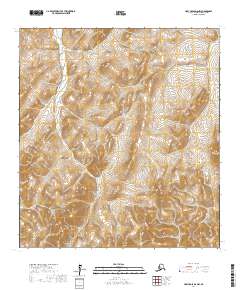
2017 Map of Holy Cross D-6 NW
USGS Topo · Published 2017About this map
Nulato Hills dominates the landscape in this remote portion of the Alaskan interior within the Kusilvak Census Area. The terrain is characterized by high, rounded ridges and deep drainage basins, reflecting the complex topography typical of this subarctic upland region. This 2017 survey provides a high-resolution look at the undeveloped wilderness, where natural contours and watershed patterns remain undisturbed by permanent settlements or modern road networks. The intricate relief mapping focuses on the physical geography of the Nulato Hills, offering an essential record of the landforms and natural hydrology for this specific section of the western Alaskan wilderness.
Find a feature on this map
7 named features on this map. Tap any name to fly to it.
Don’t see what you’re looking for? This feature index may not catch every label — zoom into the map to look around manually.
Map Details
Editions of this 2017 Holy Cross D-6 NW Map
This is the sole edition of this map. No revisions or reprints were ever made.
Other maps of this area

1951 · Unalakleet
USGS Topo · 1:250,000

1951 · St Michael
USGS Topo · 1:250,000

1951 · Holy Cross
USGS Topo · 1:250,000

1952 · Kwiguk
USGS Topo · 1:250,000

1952 · Kwiguk D-1
USGS Topo · 1:63,360

1952 · Saint Michael A-1
USGS Topo · 1:63,360

1952 · Unalakleet A-6
USGS Topo · 1:63,360
1952 · Holy Cross D-6
USGS Topo · 1:63,360

1952 · St Michael
USGS Topo · 1:250,000

1952 · Unalakleet
USGS Topo · 1:250,000