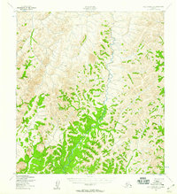
1952 Map of Holy Cross D-6
USGS Topo · Published 1959About this map
East Fork Andreafsky River dominates this interior Alaskan landscape, its winding course carving through the uplands during the early 1950s. Mapped by the Army Map Service using aerial photography, the terrain is defined by complex contour patterns and drainage systems that feed into the main river valley. This specific area, part of the Kusilvak region, shows a primitive landscape where the hydrology was the primary factor in local geography before more modern developments. The concentration of vegetation along the riverbanks contrast with the higher, exposed elevations, providing a clear look at the natural environmental corridors of the Alaskan bush during this post-war era of aerial surveying.
Find a feature on this map
1 named feature on this map. Tap any name to fly to it.
Don’t see what you’re looking for? This feature index may not catch every label — zoom into the map to look around manually.
Map Details
Editions of this 1952 Holy Cross D-6 Map
2 editions found
Other maps of this area

1951 · Unalakleet
USGS Topo · 1:250,000

1951 · St Michael
USGS Topo · 1:250,000

1951 · Holy Cross
USGS Topo · 1:250,000

1952 · Kwiguk
USGS Topo · 1:250,000

1952 · Kwiguk D-1
USGS Topo · 1:63,360

1952 · Saint Michael A-1
USGS Topo · 1:63,360

1952 · Unalakleet A-5
USGS Topo · 1:63,360

1952 · Holy Cross C-6
USGS Topo · 1:63,360

1952 · Holy Cross C-5
USGS Topo · 1:63,360

1952 · Holy Cross D-5
USGS Topo · 1:63,360