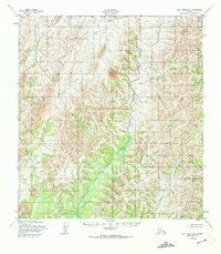
1952 Map of Holy Cross D-6
USGS Topo · Published 1974About this map
The East Fork Andreafsky River carves a winding path through this western Alaska landscape, serving as the dominant hydrological feature in a territory defined by intricate contouring. Mapped by the Army Map Service using aerial photography from the early 1950s, the terrain is presented with high-resolution topographic detail despite the absence of established roads or trails at the time of the survey. The geography is structured by the Seward Meridian, providing a clear view of the wilderness before later 20th-century developments. The map reflects a moment in Alaskan cartography where remote interior regions were first being precisely documented through photogrammetric methods, offering a window into the natural drainage patterns and landforms of the Kusilvak region.
Find a feature on this map
2 named features on this map. Tap any name to fly to it.
Don’t see what you’re looking for? This feature index may not catch every label — zoom into the map to look around manually.
Map Details
Editions of this 1952 Holy Cross D-6 Map
2 editions found
Other maps of this area

1951 · Unalakleet
USGS Topo · 1:250,000

1951 · St Michael
USGS Topo · 1:250,000

1951 · Holy Cross
USGS Topo · 1:250,000

1952 · Kwiguk
USGS Topo · 1:250,000

1952 · Kwiguk D-1
USGS Topo · 1:63,360

1952 · Saint Michael A-1
USGS Topo · 1:63,360

1952 · Unalakleet A-5
USGS Topo · 1:63,360

1952 · Holy Cross C-6
USGS Topo · 1:63,360

1952 · Holy Cross C-5
USGS Topo · 1:63,360

1952 · Holy Cross D-5
USGS Topo · 1:63,360