
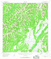
1952 Map of Holy Cross C-6
USGS Topo · Published 1959About this map
The East Fork Andreafsky River winds through the northwestern corner of this 1952 topographic study, carving a deep path through a complex network of ridges and high points. This remote stretch of the Alaska interior is defined by a high density of summit elevations and steep drainage basins, with the Chulnak River system dominating the southeastern landscape. Compiled by the Army Map Service from aerial photography taken in the early 1950s, the map reveals a wilderness entirely devoid of roads, trails, or permanent human settlements at the time of the survey. Instead, the geography is a pure expression of hydrologic patterns, where unnamed tributaries flow from high mountain passes into these two primary river arteries. The stark contrast between the intricate contour lines of the uplands and the broader, marshy valley floors provides a clear picture of the region's natural drainage and untouched topography.
Find a feature on this map
2 named features on this map. Tap any name to fly to it.
Don’t see what you’re looking for? This feature index may not catch every label — zoom into the map to look around manually.
Map Details
Editions of this 1952 Holy Cross C-6 Map
2 editions found
Other maps of this area

1951 · Holy Cross
USGS Topo · 1:250,000

1952 · Kwiguk
USGS Topo · 1:250,000

1952 · Kwiguk D-1
USGS Topo · 1:63,360

1952 · Holy Cross C-5
USGS Topo · 1:63,360

1952 · Holy Cross D-5
USGS Topo · 1:63,360

1952 · Holy Cross B-6
USGS Topo · 1:63,360

1952 · Holy Cross B-5
USGS Topo · 1:63,360

1952 · Kwiguk B-1
USGS Topo · 1:63,360

1952 · Kwiguk C-1
USGS Topo · 1:63,360
1952 · Holy Cross D-6
USGS Topo · 1:63,360