
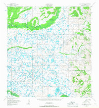
1952 Map of Holy Cross B-6
USGS Topo · Published 1959About this map
Chuilnak River winds across the northern reaches of this mid-century topographic study, defining a landscape dominated by complex drainage patterns and numerous small ponds. Situated in the Alaskan interior near the confluence of the Yukon and Kuskokwim basins, the terrain transitions from low-lying water systems to the elevated ridges in the east. Evidence of seasonal habitation or subsistence use appears near Allman Lake, where isolated Cabins are noted along the shore. The southern portion of the map is marked by the course of the Nageethluk River, which cuts through the foothills of the rising eastern highlands. This survey, based on aerial photography from the early 1950s, documents the intricate wetland network and natural landmarks used by travelers and residents in this part of Alaska before modern development significantly altered the region's accessibility.
Find a feature on this map
4 named features on this map. Tap any name to fly to it.
Don’t see what you’re looking for? This feature index may not catch every label — zoom into the map to look around manually.
Map Details
Editions of this 1952 Holy Cross B-6 Map
2 editions found
Other maps of this area

1951 · Holy Cross
USGS Topo · 1:250,000

1951 · Holy Cross A-5
USGS Topo · 1:63,360

1952 · Kwiguk
USGS Topo · 1:250,000

1952 · Holy Cross C-6
USGS Topo · 1:63,360

1952 · Holy Cross C-5
USGS Topo · 1:63,360

1952 · Holy Cross B-5
USGS Topo · 1:63,360

1952 · Kwiguk A-1
USGS Topo · 1:63,360

1952 · Kwiguk B-1
USGS Topo · 1:63,360

1952 · Holy Cross A-6
USGS Topo · 1:63,360

1952 · Kwiguk C-1
USGS Topo · 1:63,360