
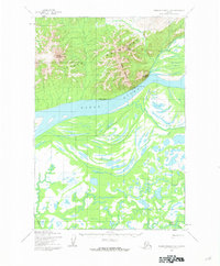
1951 Map of Holy Cross A-5
USGS Topo · Published 1959About this map
Nageethluk River winds through the northern portion of this interior Alaskan landscape, serving as a primary drainage for the surrounding unnamed Mountains. The terrain is characterized by a dense network of high ridges and deep valleys, where Gray Creek and Kak Creek descend toward the main river systems. To the southeast, the Stuyahok River cuts through the topography, illustrating the complex hydrology of the Yukon-Kuskokwim Delta region. While the landscape is largely defined by its natural features, the inclusion of Trails indicates the established overland routes used for travel and subsistence during the mid-twentieth century. This 1951 aerial survey, finalized for civil use later in the decade, provides a technical view of a region defined by its elevation changes and isolated waterways.
Find a feature on this map
6 named features on this map. Tap any name to fly to it.
Don’t see what you’re looking for? This feature index may not catch every label — zoom into the map to look around manually.
Map Details
Editions of this 1951 Holy Cross A-5 Map
This is the sole edition of this map. No revisions or reprints were ever made.
Other maps of this area

1947 · Russian Mission
USGS Topo · 1:250,000

1950 · Russian Mission
USGS Topo · 1:250,000

1951 · Holy Cross
USGS Topo · 1:250,000

1952 · Holy Cross A-4
USGS Topo · 1:63,360

1952 · Holy Cross B-6
USGS Topo · 1:63,360

1952 · Holy Cross B-5
USGS Topo · 1:63,360

1952 · Holy Cross A-6
USGS Topo · 1:63,360

1952 · Holy Cross B-4
USGS Topo · 1:63,360

1952 · Holy Cross
USGS Topo · 1:250,000
1952 · Russian Mission D-6
USGS Topo · 1:63,360