
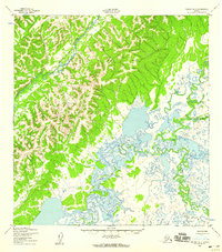
1952 Map of Kwiguk B-1
USGS Topo · Published 1959About this map
The East Fork Andreafsky River flows through a landscape defined by the transition from upland terrain to an intricate system of wetlands and meandering waterways. Mapped in the early 1950s by the Army Map Service, this sheet illustrates the complex hydrology of the region before significant modern development. The Chuilnak River and Nageethluk River dominate the lower elevations, where they form a dense network of oxbows and marshlands. This geography suggests a traditional reliance on seasonal water routes for movement through the territory. The absence of roads or trails, as noted by the Corps of Engineers, highlights the untouched nature of these river systems during this period of Alaskan history.
Find a feature on this map
3 named features on this map. Tap any name to fly to it.
Don’t see what you’re looking for? This feature index may not catch every label — zoom into the map to look around manually.
Map Details
Editions of this 1952 Kwiguk B-1 Map
2 editions found
Other maps of this area

1951 · Holy Cross
USGS Topo · 1:250,000

1952 · Kwiguk
USGS Topo · 1:250,000

1952 · Kwiguk B-2
USGS Topo · 1:63,360

1952 · Kwiguk C-2
USGS Topo · 1:63,360

1952 · Holy Cross C-6
USGS Topo · 1:63,360

1952 · Holy Cross B-6
USGS Topo · 1:63,360

1952 · Kwiguk A-2
USGS Topo · 1:63,360

1952 · Kwiguk A-1
USGS Topo · 1:63,360

1952 · Holy Cross A-6
USGS Topo · 1:63,360

1952 · Kwiguk C-1
USGS Topo · 1:63,360