
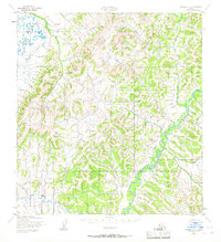
1952 Map of Kwiguk C-2
USGS Topo · Published 1958About this map
The Andreafsky River snakes through the southeastern corner of this terrain, which was documented by the Army Map Service using aerial photography in the early 1950s. The landscape is defined by its drainage systems, with the Pastolik River flowing through the northwestern lowlands and Allen Creek marking the southwestern quadrant. These river courses are the primary identifiers on a sheet otherwise characterized by significant topographic relief, with unnumbered peaks and ridges rising between the water bodies. The lack of roads or named settlements reflects the remote nature of this portion of the Alaska Second Judicial Division during this era, making the primary watercourses essential for orienting the landscape.
Find a feature on this map
3 named features on this map. Tap any name to fly to it.
Don’t see what you’re looking for? This feature index may not catch every label — zoom into the map to look around manually.
Map Details
Editions of this 1952 Kwiguk C-2 Map
2 editions found
Other maps of this area

1952 · Kwiguk
USGS Topo · 1:250,000

1952 · Kwiguk D-1
USGS Topo · 1:63,360

1952 · Kwiguk B-3
USGS Topo · 1:63,360

1952 · Kwiguk B-2
USGS Topo · 1:63,360

1952 · Kwiguk D-2
USGS Topo · 1:63,360

1952 · Kwiguk D-3
USGS Topo · 1:63,360

1952 · Kwiguk C-3
USGS Topo · 1:63,360

1952 · Kwiguk B-1
USGS Topo · 1:63,360

1952 · Kwiguk C-1
USGS Topo · 1:63,360
2018 · Kwiguk C-1 NW
USGS Topo · 1:25,000