
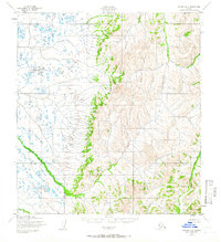
1952 Map of Kwiguk D-2
USGS Topo · Published 1958About this map
Pastoliak River meanders across a vast wetland plain in this mid-century topographic record of the Kusilvak region. The western half of the landscape is dominated by a dense network of tundra ponds and drainage patterns that feed into the river's main channel. Transitioning toward the east, the terrain rises sharply into a series of ridges and upland peaks, where the Pikmiktalik River cuts through the high ground. This 1950s survey, based on 1951 aerial photography, illustrates the stark contrast between the low-lying coastal marshes and the interior highlands before any modern infrastructure or roads reached this part of Alaska.
Find a feature on this map
2 named features on this map. Tap any name to fly to it.
Don’t see what you’re looking for? This feature index may not catch every label — zoom into the map to look around manually.
Map Details
Editions of this 1952 Kwiguk D-2 Map
2 editions found
Other maps of this area

1951 · St Michael
USGS Topo · 1:250,000

1952 · Kwiguk
USGS Topo · 1:250,000

1952 · Kwiguk D-1
USGS Topo · 1:63,360

1952 · Kwiguk C-2
USGS Topo · 1:63,360

1952 · Kwiguk D-3
USGS Topo · 1:63,360
1952 · Saint Michael A-3
USGS Topo · 1:63,360

1952 · Kwiguk C-3
USGS Topo · 1:63,360

1952 · Saint Michael A-1
USGS Topo · 1:63,360

1952 · Saint Michael A-2
USGS Topo · 1:63,360

1952 · Kwiguk C-1
USGS Topo · 1:63,360