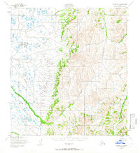
1952 Map of Kwiguk D-2
USGS Topo · Published 1965About this map
The Pastolik River meanders across the low-lying western reaches of this 1952 Alaskan coastal interior terrain, where the marshy tundra of the Yukon Delta gives way to the rising elevations of the east. These eastern highlands are defined by the watershed of the Pikmiktalik River, which cuts through narrow valleys before descending toward the coastal plains. Based on 1951 aerial photography by the Army Map Service, the survey captures a landscape of extreme contrast, where thousands of small lakes and ponds dominate the flat western half of the quadrangle. This transition from aquatic tundra to defined river valleys reflects the complex drainage patterns of the region before any modern infrastructure or permanent settlements were documented by the Geological Survey.
Find a feature on this map
2 named features on this map. Tap any name to fly to it.
Don’t see what you’re looking for? This feature index may not catch every label — zoom into the map to look around manually.
Map Details
Editions of this 1952 Kwiguk D-2 Map
2 editions found
Other maps of this area

1951 · St Michael
USGS Topo · 1:250,000

1952 · Kwiguk
USGS Topo · 1:250,000

1952 · Kwiguk D-1
USGS Topo · 1:63,360

1952 · Kwiguk C-2
USGS Topo · 1:63,360

1952 · Kwiguk D-2
USGS Topo · 1:63,360

1952 · Kwiguk D-3
USGS Topo · 1:63,360
1952 · Saint Michael A-3
USGS Topo · 1:63,360

1952 · Kwiguk C-3
USGS Topo · 1:63,360

1952 · Saint Michael A-1
USGS Topo · 1:63,360

1952 · Saint Michael A-2
USGS Topo · 1:63,360