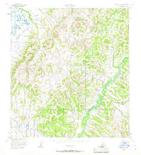
1952 Map of Kwiguk C-2
USGS Topo · Published 1967About this map
The Andreafsky River winds through this subarctic interior, defining the drainage patterns of the eastern portion of the quadrangle. Mapped in the early 1950s by the Army Map Service, the landscape is characterized by a dense network of watercourses and elevation contours that reveal the intricate drainage basin of the Pastolik River in the northwest. In the southwest, Allen Creek cuts through the terrain, illustrating the hydrologic connection between the higher elevations and the lower river valleys. The lack of named settlements or roads during this era underscores the undeveloped nature of the region, focusing instead on the natural topography and the essential waterways used for navigation and subsistence in this part of Alaska.
Find a feature on this map
3 named features on this map. Tap any name to fly to it.
Don’t see what you’re looking for? This feature index may not catch every label — zoom into the map to look around manually.
Map Details
Editions of this 1952 Kwiguk C-2 Map
2 editions found
Other maps of this area

1952 · Kwiguk
USGS Topo · 1:250,000

1952 · Kwiguk D-1
USGS Topo · 1:63,360

1952 · Kwiguk B-3
USGS Topo · 1:63,360

1952 · Kwiguk B-2
USGS Topo · 1:63,360

1952 · Kwiguk C-2
USGS Topo · 1:63,360

1952 · Kwiguk D-2
USGS Topo · 1:63,360

1952 · Kwiguk D-3
USGS Topo · 1:63,360

1952 · Kwiguk C-3
USGS Topo · 1:63,360

1952 · Kwiguk B-1
USGS Topo · 1:63,360

1952 · Kwiguk C-1
USGS Topo · 1:63,360