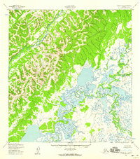
1952 Map of Kwiguk B-1
USGS Topo · Published 1959About this map
The East Fork Andreafsky River winds through the northwestern corner of this 1952 topographic study, showcasing a wilderness landscape defined by sharp elevation shifts and complex drainage patterns. Produced by the Corps of Engineers and the Geological Survey, the map details a territory where water dictates the geography. The southern and eastern portions of the quadrangle are dominated by the meandering paths of the Chuilnak River and the Nageth Luk River, which snake through low-lying wetlands punctuated by numerous small ponds and sloughs. This mapping effort, based on aerial photography from 1951, provides a precise look at the alluvial plains and upland ridges before modern changes, noting the absence of any established roads or trails in this part of the Alaskan interior.
Find a feature on this map
4 named features on this map. Tap any name to fly to it.
Don’t see what you’re looking for? This feature index may not catch every label — zoom into the map to look around manually.
Map Details
Editions of this 1952 Kwiguk B-1 Map
2 editions found
Other maps of this area

1951 · Holy Cross
USGS Topo · 1:250,000

1952 · Kwiguk
USGS Topo · 1:250,000

1952 · Kwiguk B-2
USGS Topo · 1:63,360

1952 · Kwiguk C-2
USGS Topo · 1:63,360

1952 · Holy Cross C-6
USGS Topo · 1:63,360

1952 · Holy Cross B-6
USGS Topo · 1:63,360

1952 · Kwiguk A-2
USGS Topo · 1:63,360

1952 · Kwiguk A-1
USGS Topo · 1:63,360

1952 · Kwiguk B-1
USGS Topo · 1:63,360

1952 · Holy Cross A-6
USGS Topo · 1:63,360