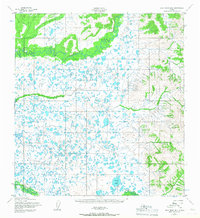
1952 Map of Holy Cross B-6
USGS Topo · Published 1967About this map
Atchuelinguk River meanders across the northern reaches of this Alaskan landscape, defining a terrain of dense watercourses and countless unnamed lakes. In the early 1950s, this area of the Yukon-Kuskokwim Delta was largely unsettled, characterized by a complex network of seasonal drainage and marshlands. To the south, the Nageethluk River winds past Allman Lake, where small, nameless Cabins represent the only structural footprint of human activity recorded by the Army Map Service. The placement of these remote outposts near the water suggests their importance for trapping, fishing, or subsistence travel during the mid-century era. The topography transitions from the low-lying lake regions in the west to significant elevations along the eastern border, providing a clear record of the natural watershed before contemporary shifts in the Arctic environment.
Find a feature on this map
4 named features on this map. Tap any name to fly to it.
Don’t see what you’re looking for? This feature index may not catch every label — zoom into the map to look around manually.
Map Details
Editions of this 1952 Holy Cross B-6 Map
2 editions found
Other maps of this area

1951 · Holy Cross
USGS Topo · 1:250,000

1951 · Holy Cross A-5
USGS Topo · 1:63,360

1952 · Kwiguk
USGS Topo · 1:250,000

1952 · Holy Cross C-6
USGS Topo · 1:63,360

1952 · Holy Cross C-5
USGS Topo · 1:63,360

1952 · Holy Cross B-6
USGS Topo · 1:63,360

1952 · Holy Cross B-5
USGS Topo · 1:63,360

1952 · Kwiguk A-1
USGS Topo · 1:63,360

1952 · Kwiguk B-1
USGS Topo · 1:63,360

1952 · Holy Cross A-6
USGS Topo · 1:63,360