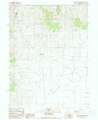
1990 Map of Home Station Gap
USGS Topo · Published 1990About this map
Home Station Gap serves as a natural corridor between the high peaks of the Fish Creek Mountains and the Augusta Mountains, marking a transition from high desert peaks into the broad expanse of Antelope Valley. This 1990 provisional survey records the remote hydrology of the Lander and Pershing County line, where water sources like Hess Spring and a Water Tank were critical infrastructure for the arid high basin. The landscape is primarily defined by drainage patterns like Home Station Wash and the presence of scattered wells, suggesting a reliance on groundwater for any activity in this corner of the Great Basin. Evidence of industrial exploration or geological sampling appears in the valley floor, noted by a specific Drill Hole, while the extensive network of 4wd tracks indicates the limited but essential routes through the rugged terrain.
Find a feature on this map
13 named features on this map. Tap any name to fly to it.
Don’t see what you’re looking for? This feature index may not catch every label — zoom into the map to look around manually.
Map Details
Editions of this 1990 Home Station Gap Map
This is the sole edition of this map. No revisions or reprints were ever made.
Other maps of this area

1932 · Sonoma Range
USGS Topo · 1:250,000

1939 · Sonoma Range
USGS Topo · 1:250,000

1955 · Millett
USGS Topo · 1:250,000

1955 · Winnemucca
USGS Topo · 1:250,000

1958 · Winnemucca
USGS Topo · 1:250,000

1959 · Millett
USGS Topo · 1:250,000

1961 · Cain Mountain
USGS Topo · 1:62,500

1961 · Mt. Moses
USGS Topo · 1:62,500

1962 · Winnemucca
USGS Topo · 1:250,000

1966 · Shoshone Meadows
USGS Topo · 1:62,500