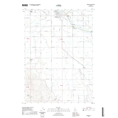
2020 Map of Homedale
USGS Topo · Published 2020About this map
The Snake River winds along the border of Canyon Co and Owyhee Co, anchoring an agricultural landscape defined by a complex irrigation network. The town of Homedale serves as a central hub, surrounded by a grid of rural roads and an extensive system of waterways including the A Line Canal, B Line Canal, and the Fargo Wasteway. This infrastructure supports the fields between Owyhee Heights and the riverbanks where Rabbit Island and Clarks Island are positioned. To the south, the terrain shifts dramatically as the valley floor meets the foothills of the Owyhee Mountains. Distinctive geological features like Rattlesnake Butte and Flat Top Butte rise above the drainage basins of Succor Cr and Poison Cr. Local landmarks such as the Homedale Municipal Airport and the Marsing-Homedale Cem provide clear points of reference for those tracing family history or land ownership in this corner of southwestern Idaho.
Find a feature on this map
99 named features on this map. Tap any name to fly to it.
Don’t see what you’re looking for? This feature index may not catch every label — zoom into the map to look around manually.
Map Details
Editions of this 2020 Homedale Map
This is the sole edition of this map. No revisions or reprints were ever made.
Other maps of this area

1892 · Silver City
USGS Topo · 1:125,000

1894 · Silver City
USGS Topo · 1:125,000

1898 · Nampa
USGS Topo · 1:125,000

1898 · Silver City
USGS Topo · 1:125,000

1906 · Mitchell Butte
USGS Topo · 1:125,000

1955 · Boise
USGS Topo · 1:250,000

1957 · Opalene Gulch
USGS Topo · 1:24,000

1957 · Wilder
USGS Topo · 1:24,000

1957 · Sands Basin
USGS Topo · 1:62,500

1957 · Notus
USGS Topo · 1:24,000