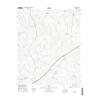
2017 Map of Homer
USGS Topo · Published 2017About this map
Homer serves as a central hub in this corner of Northeast Georgia, where the Hudson River and its numerous tributaries like Nails Cr and Grove Creek define the rolling topography. The landscape is dotted with small settlements and family-named landmarks that reflect deep roots in the region. Near the banks of Grove Creek, the New Salem Covered Bridge remains a notable architectural landmark, situated just north of the New Salem Cem.
Find a feature on this map
117 named features on this map. Tap any name to fly to it.
Don’t see what you’re looking for? This feature index may not catch every label — zoom into the map to look around manually.
Map Details
Editions of this 2017 Homer Map
This is the sole edition of this map. No revisions or reprints were ever made.
Other maps of this area

1891 · Gainesville
USGS Topo · 1:125,000

1891 · Carnesville
USGS Topo · 1:125,000

1954 · Greenville
USGS Topo · 1:250,000

1958 · Greenville
USGS Topo · 1:250,000

1964 · Commerce
USGS Topo · 1:24,000

1964 · Maysville
USGS Topo · 1:24,000

1964 · Ila
USGS Topo · 1:24,000

1964 · Ashland
USGS Topo · 1:24,000
1964 · Lake Russell
USGS Topo · 1:24,000
1964 · Baldwin
USGS Topo · 1:24,000