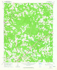
1964 Map of Homer
USGS Topo · Published 1965About this map
The Hudson River and its numerous tributaries, including Webb Creek and Carlan Creek, carve a complex network through the rural landscape of Banks County in the mid-1960s. The town of Homer serves as a central hub, flanked by the County Sch and Homer Ch. This survey illustrates a deeply rooted community where local life centers around dispersed settlements like Jewelville and Grove Level, and a dense concentration of neighborhood landmarks. Genealogists will find significant value in the numerous family-linked sites, such as the Wilmot Cem, Thomas Cem, and Holland Cem. The presence of Davis Academy and the Covered Bridge over the river reflects an era of transitioning infrastructure, while the distribution of numerous country churches, including Bethany Ch and New Salem Ch, provides a clear view of the social geography of the Georgia Piedmont during this period.
Find a feature on this map
41 named features on this map. Tap any name to fly to it.
Don’t see what you’re looking for? This feature index may not catch every label — zoom into the map to look around manually.
Map Details
Editions of this 1964 Homer Map
2 editions found
Other maps of this area

1891 · Gainesville
USGS Topo · 1:125,000

1891 · Carnesville
USGS Topo · 1:125,000

1954 · Greenville
USGS Topo · 1:250,000

1958 · Greenville
USGS Topo · 1:250,000

1964 · Commerce
USGS Topo · 1:24,000

1964 · Maysville
USGS Topo · 1:24,000

1964 · Ila
USGS Topo · 1:24,000

1964 · Ashland
USGS Topo · 1:24,000
1964 · Lake Russell
USGS Topo · 1:24,000
1964 · Baldwin
USGS Topo · 1:24,000