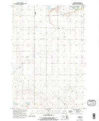
1990 Map of Homer
USGS Topo · Published 1995About this map
The James River cuts through the northeast corner of this Stutsman County landscape, providing a rare stretch of wooded riparian terrain amidst a vast expanse of prairie potholes and agricultural sections. This late-twentieth-century revision, based on earlier mid-century surveys, shows a rural network centered on the township boundaries of Woodbury, Homer, Sydney, and Corwin. Notable institutional landmarks include the State Hospital Cem and the extensive grounds of the Northern Prairie Wildlife Research Area. Small rail-aligned settlements and trackside points like Jamestown Junction, Homer, and Kloze serve as the primary navigational markers across the gridded section lines. The map reveals the slow evolution of the land, where numerous small depressions and sloughs persist alongside modern infrastructure like the prominent Communication Tower clusters.
Find a feature on this map
14 named features on this map. Tap any name to fly to it.
Don’t see what you’re looking for? This feature index may not catch every label — zoom into the map to look around manually.
Map Details
Editions of this 1990 Homer Map
This is the sole edition of this map. No revisions or reprints were ever made.
Other maps of this area

1896 · Jamestown
USGS Topo · 1:125,000

1951 · Jamestown
USGS Topo · 1:24,000

1951 · Eldridge SE
USGS Topo · 1:24,000

1952 · Eldridge
USGS Topo · 1:24,000

1952 · Homer
USGS Topo · 1:24,000

1952 · Ypsilanti
USGS Topo · 1:24,000

1952 · Bloom
USGS Topo · 1:24,000

1953 · Jamestown
USGS Topo · 1:250,000

1953 · Montpelier
USGS Topo · 1:24,000

1953 · Montpelier NW
USGS Topo · 1:24,000