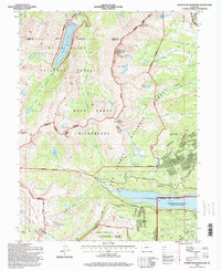
1994 Map of Homestake Reservoir
USGS Topo · Published 1998About this map
Turquoise Lake and the Homestake Reservoir dominate this high-altitude landscape along the Continental Divide, where the borders of Eagle, Pitkin, and Lake counties converge. The map documents a complex network of water management and industrial history, evidenced by a high density of subterranean infrastructure. Numerous engineering feats are marked, including the Hagerman Tunnel, Canlton Tunnel, and the Boustead Tunnel, which pierce the mountain ridges to move water and rail traffic. To the east, the legacy of Colorado's mining era is visible through a concentration of named shafts and adits such as the Saint Kevin Shaft, Dinero Tunnel, and the Homestake Mine. These workings sit nestled between prominent peaks like Homestake Peak and Sugarloaf Mountain, illustrating the intense search for mineral wealth in the rugged terrain of the Holy Cross Wilderness and San Isabel National Forest.
Find a feature on this map
59 named features on this map. Tap any name to fly to it.
Don’t see what you’re looking for? This feature index may not catch every label — zoom into the map to look around manually.
Map Details
Editions of this 1994 Homestake Reservoir Map
This is the sole edition of this map. No revisions or reprints were ever made.
Other maps of this area

1889 · Leadville
USGS Topo · 1:125,000

1891 · Leadville
USGS Topo · 1:125,000

1909 · Mount Jackson
USGS Topo · 1:125,000

1911 · Mount Jackson
USGS Topo · 1:125,000

1935 · Mount Elbert
USGS Topo · 1:62,500

1938 · Mount Elbert
USGS Topo · 1:62,500

1939 · Mount Elbert
USGS Topo · 1:62,500

1942 · Leadville
USGS Topo · 1:125,000

1949 · Holy Cross
USGS Topo · 1:62,500

1951 · Holy Cross
USGS Topo · 1:62,500