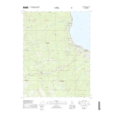
2018 Map of Homewood
USGS Topo · Published 2018About this map
Lake Tahoe and its western shoreline dominate this landscape, where the settlements of Homewood, Tahoma, and Idlewild line the water's edge along W Lake Blvd. The terrain rises sharply away from McKinney Bay, leading into the high-elevation wilderness of the Tahoe National Forest and Eldorado National Forest. This survey captures the complex intersection of recreation and geography, detailing the numerous alpine water bodies such as Miller Lake, Lily Lake, and Quail Lake tucked behind prominent summits like Ellis Peak and Twin Peaks. Historically significant routes, including the PCT - Pacific Crest and the Tahoe Rim Trail, weave through the western ridges. Evidence of backcountry exploration is clear through specialized routes like the Rubicon Jeep trail and the Barker Meadow OHV path, providing a record of how the Sierra Nevada was navigated and settled before more modern developments.
Find a feature on this map
81 named features on this map. Tap any name to fly to it.
Don’t see what you’re looking for? This feature index may not catch every label — zoom into the map to look around manually.
Map Details
Editions of this 2018 Homewood Map
This is the sole edition of this map. No revisions or reprints were ever made.
Other maps of this area

1889 · Pyramid Peak
USGS Topo · 1:125,000

1891 · Truckee
USGS Topo · 1:125,000

1891 · Pyramid Peak
USGS Topo · 1:125,000

1893 · Truckee
USGS Topo · 1:125,000

1895 · Pyramid Peak
USGS Topo · 1:125,000

1895 · Truckee
USGS Topo · 1:125,000

1896 · Pyramid Peak
USGS Topo · 1:125,000

1932 · Truckee
USGS Topo · 1:96,000

1940 · Truckee
USGS Topo · 1:125,000

1947 · Sacramento
USGS Topo · 1:250,000