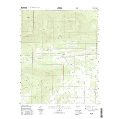
2017 Map of Hon
USGS Topo · Published 2017About this map
Poteau River valley settlements define the character of this western Arkansas survey, where the small communities of Hon and Winfield sit between the prominent heights of Poteau Mtn and Chalybeate Mtn. Much of the northern terrain is occupied by the Ouachita National Forest, characterized by deep cuts like Rock Canyon and peaks such as Hickory Knob. Local history is anchored by family and community landmarks, including Hon Cem, Anthony Cem, and Behorn Cem. The landscape reveals a managed watershed with numerous sites such as Poteau River Watershed Site Eight Lake and Poteau River Watershed Site 16 Lake. Transportation in the area relies on a network of rural routes like Poteau Mtn Rd and Strickland Loop, which connect the valley floors to the surrounding ridges.
Find a feature on this map
78 named features on this map. Tap any name to fly to it.
Don’t see what you’re looking for? This feature index may not catch every label — zoom into the map to look around manually.
Map Details
Editions of this 2017 Hon Map
This is the sole edition of this map. No revisions or reprints were ever made.
Other maps of this area

1879 · Poteau Mountain
USGS Topo · 1:62,500

1887 · Poteau Mountain #1
USGS Topo · 1:62,500

1887 · Poteau Mountain #2
USGS Topo · 1:62,500

1887 · Greenwood
USGS Topo · 1:62,500

1890 · Fort Smith
USGS Topo · 1:125,000

1890 · Poteau Mountain
USGS Topo · 1:125,000

1899 · Poteau Mountain
USGS Topo · 1:125,000

1906 · Barber
USGS Topo · 1:62,500

1939 · Waldron
USGS Topo · 1:62,500

1940 · Waldron
USGS Topo · 1:62,500