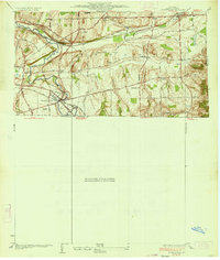
1934 Map of Honeoye Falls
USGS Topo · Published 1934About this map
Honeoye Falls and the town of Mendon define this landscape during the mid-1930s, showing a well-established network of rural schools and family burial grounds. The Lehigh Valley railroad and Rochester Junction underscore the area's importance as a transportation corridor between major regional centers. A series of numbered schoolhouses, from School No 10 to School No 4, are spaced throughout the countryside, marking the centers of small rural districts that have since consolidated.
Find a feature on this map
32 named features on this map. Tap any name to fly to it.
Don’t see what you’re looking for? This feature index may not catch every label — zoom into the map to look around manually.
Map Details
Editions of this 1934 Honeoye Falls Map
This is the sole edition of this map. No revisions or reprints were ever made.
Other maps of this area

1895 · Rochester
USGS Topo · 1:62,500

1898 · Rochester
USGS Topo · 1:62,500

1900 · Macedon
USGS Topo · 1:62,500

1900 · Canandaigua
USGS Topo · 1:62,500

1901 · Honeoye
USGS Topo · 1:62,500

1903 · Canandaigua
USGS Topo · 1:62,500

1904 · Honeoye
USGS Topo · 1:62,500

1912 · Rochester
USGS Topo · 1:62,500

1920 · Rochester
USGS Topo · 1:62,500

1931 · Mendon Ponds
USGS Topo · 1:24,000