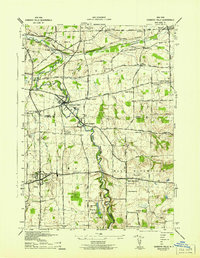
1942 Map of Honeoye Falls
USGS Topo · Published 1942About this map
Honeoye Creek and the Lehigh Valley Railroad define the industrial and agricultural corridors of this region during the early 1940s. The village of Honeoye Falls serves as a primary hub where rail lines intersect, supporting a landscape dotted with numerous local landmarks such as Rochester Junction and Sibleyville. The map illustrates a dense network of one-room schoolhouses, including School No 12 and School No 15, marking the traditional social centers of townships like Mendon and Lima.
Find a feature on this map
60 named features on this map. Tap any name to fly to it.
Don’t see what you’re looking for? This feature index may not catch every label — zoom into the map to look around manually.
Map Details
Editions of this 1942 Honeoye Falls Map
This is the sole edition of this map. No revisions or reprints were ever made.
Other maps of this area

1895 · Rochester
USGS Topo · 1:62,500

1898 · Rochester
USGS Topo · 1:62,500

1900 · Macedon
USGS Topo · 1:62,500

1900 · Canandaigua
USGS Topo · 1:62,500

1901 · Honeoye
USGS Topo · 1:62,500

1903 · Canandaigua
USGS Topo · 1:62,500

1904 · Honeoye
USGS Topo · 1:62,500

1912 · Rochester
USGS Topo · 1:62,500

1920 · Rochester
USGS Topo · 1:62,500

1931 · Mendon Ponds
USGS Topo · 1:24,000