
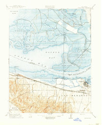
1918 Map of Honker Bay
USGS Topo · Published 1918About this map
Industrial development and maritime commerce converge at the junction of Suisun Bay and the Sacramento River on this 1918 sheet. The southern shore is anchored by Pittsburg, where the Pittsburg Sta serves as a vital rail node for the Southern Pacific and the Atchison Topeka and Santa Fe lines. The landscape transitions from the developed waterfront at West Pittsburg and Nichols to the complex delta marshlands of Grizzly Island and Hammond Island. To the north, the isolated settlement of Birds Landing and various steamboat docks like Yolo Landing and Duttons Landing reflect the era’s reliance on waterborne transport through Monte Zuma Slough. The Mt Diablo Meridian bisects the bay, marking a critical surveying line through Chipps Island and the shallow waters of Honker Bay.
Find a feature on this map
55 named features on this map. Tap any name to fly to it.
Don’t see what you’re looking for? This feature index may not catch every label — zoom into the map to look around manually.
Map Details
Editions of this 1918 Honker Bay Map
2 editions found
Other maps of this area

1896 · Carquinez Strait
USGS Topo · 1:62,500

1896 · Mt. Diablo
USGS Topo · 1:62,500

1897 · Concord
USGS Topo · 1:62,500

1898 · Karquines
USGS Topo · 1:62,500

1898 · Mt. Diablo
USGS Topo · 1:62,500

1901 · Karquines
USGS Topo · 1:62,500

1902 · Napa
USGS Topo · 1:125,000

1907 · Antioch
USGS Topo · 1:62,500

1908 · Antioch
USGS Topo · 1:62,500

1915 · Concord
USGS Topo · 1:62,500