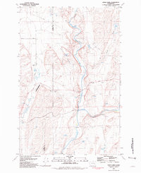
1981 Map of Honn Lakes
USGS Topo · Published 1981About this map
Rock Creek winds through the basalt-coulee landscape of the Adams and Whitman County line, creating a complex drainage network characterized by seasonal water bodies and dramatic falls. This early 1980s survey captures a rural landscape where the Palouse River and its tributaries dictate the placement of roads and early aviation infrastructure. The land is marked by several family-named water features and landmarks, including Honn Lakes, Winn Lakes, and Lehrbas Spring, which served as critical resources for the local agricultural and ranching economy.
Find a feature on this map
25 named features on this map. Tap any name to fly to it.
Don’t see what you’re looking for? This feature index may not catch every label — zoom into the map to look around manually.
Map Details
Editions of this 1981 Honn Lakes Map
This is the sole edition of this map. No revisions or reprints were ever made.
Other maps of this area

1950 · La Crosse
USGS Topo · 1:62,500

1950 · Benge
USGS Topo · 1:62,500

1952 · La Crosse
USGS Topo · 1:62,500

1952 · Benge
USGS Topo · 1:62,500

1953 · Walla Walla
USGS Topo · 1:250,000

1953 · Ritzville
USGS Topo · 1:250,000

1955 · Pullman
USGS Topo · 1:250,000

1955 · Spokane
USGS Topo · 1:250,000

1958 · Spokane
USGS Topo · 1:250,000

1958 · Pullman
USGS Topo · 1:250,000