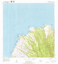
1956 Map of Honolua
USGS Topo · Published 1979About this map
The northwest coast of Maui in the mid-1950s is defined by a landscape of coastal settlements and rugged volcanic drainages. The Honoapiilani Highway serves as the primary artery connecting shoreline points like Honolua and the village of Honokahua, which then served as a local post office hub. The interior is dominated by the West Maui Forest Reserve, where deep gulches like Mokupeia Gulch and Punaha Gulch cut through the high terrain of Puu Kaeo.
Find a feature on this map
65 named features on this map. Tap any name to fly to it.
Don’t see what you’re looking for? This feature index may not catch every label — zoom into the map to look around manually.
Map Details
Editions of this 1956 Honolua Map
3 editions found
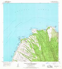
Other maps of this area

1952 · Halawa
USGS Topo · 1:24,000

1954 · Maui
USGS Topo · 1:250,000

1955 · Wailuku
USGS Topo · 1:24,000

1955 · Kahakuloa
USGS Topo · 1:24,000

1956 · Lahaina
USGS Topo · 1:24,000

1956 · Honolua
USGS Topo · 1:24,000

1966 · Maui
USGS Topo · 1:250,000

1968 · Halawa
USGS Topo · 1:24,000

1974 · Maui
USGS Topo · 1:250,000

1977 · Wailuku
USGS Topo · 1:24,000