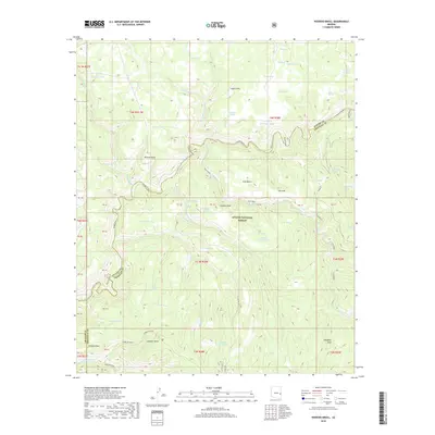
2018 Map of Hoodoo Knoll
USGS Topo · Published 2018About this map
The Black River carves a deep, winding path through this portion of the Apache National Forest, defining the boundary between Apache and Greenlee counties. This high-altitude landscape is characterized by a network of drainage systems like Wildcat Cr and Fish Creek, which flow toward the river through distinct landforms such as Fish Bench and Wildcat Point. The area's reliance on managed water sources is evident in the numerous tanks and springs scattered across the terrain, including Coyote Sink, Turkey Tank, and Mushroom Seep. To the south, the terrain rises toward Gobbler Point and the prominent Bear Wallow area. Pockets of level ground such as Paradise Park and small water bodies like Elk Lake and McKibbins Pond punctuate the ridges, while Hoodoo Knoll stands as a central landmark amidst the forest's complex topography.
Find a feature on this map
54 named features on this map. Tap any name to fly to it.
Don’t see what you’re looking for? This feature index may not catch every label — zoom into the map to look around manually.
Map Details
Editions of this 2018 Hoodoo Knoll Map
This is the sole edition of this map. No revisions or reprints were ever made.
Other maps of this area

1922 · Nutrioso
USGS Topo · 1:125,000

1954 · Clifton
USGS Topo · 1:250,000

1957 · Clifton
USGS Topo · 1:250,000

1958 · Clifton
USGS Topo · 1:250,000

1958 · Hannagan Meadow
USGS Topo · 1:62,500

1958 · Big Lake
USGS Topo · 1:62,500

1962 · Clifton
USGS Topo · 1:250,000

1967 · Freezeout Mountain
USGS Topo · 1:24,000
1967 · Bonito Rock
USGS Topo · 1:24,000
1967 · Maverick
USGS Topo · 1:24,000