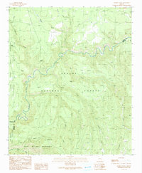
1991 Map of Hoodoo Knoll
USGS Topo · Published 1991About this map
The Black River carves a deep, winding path through this corner of Eastern Arizona, serving as a significant geographical boundary between the Fort Apache Indian Reservation and the Apache National Forest. This 1991 provisional survey documents a landscape defined by high-elevation landforms and complex water systems, including Hoodoo Knoll and the extensive Bear Wallow Wilderness to the south. The terrain is marked by dramatic points and benches, such as Wildcat Point and Fish Bench, which overlook a network of drainages including Snake Creek and Conklin Creek. Remote access is indicated by the Pack Trail and Wallow Pack Trail, while small-scale human imprints like McKibbins Pond and a lone Gravel Pit suggest localized utility within these protected public and tribal lands. The intersection of Greenlee, Graham, and Apache counties near the San Carlos Indian Reservation boundary highlights the map's value for understanding regional administrative limits.
Find a feature on this map
23 named features on this map. Tap any name to fly to it.
Don’t see what you’re looking for? This feature index may not catch every label — zoom into the map to look around manually.
Map Details
Editions of this 1991 Hoodoo Knoll Map
This is the sole edition of this map. No revisions or reprints were ever made.
Other maps of this area

1922 · Nutrioso
USGS Topo · 1:125,000

1954 · Clifton
USGS Topo · 1:250,000

1957 · Clifton
USGS Topo · 1:250,000

1958 · Clifton
USGS Topo · 1:250,000

1958 · Hannagan Meadow
USGS Topo · 1:62,500

1958 · Big Lake
USGS Topo · 1:62,500

1962 · Clifton
USGS Topo · 1:250,000

1967 · Freezeout Mountain
USGS Topo · 1:24,000
1967 · Bonito Rock
USGS Topo · 1:24,000
1967 · Maverick
USGS Topo · 1:24,000