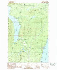
1985 Map of Hoodsport
USGS Topo · Published 1985About this map
Lake Cushman and the Hood Canal shoreline dominate this mid-1980s landscape, illustrating a region shaped by hydroelectric development and recreational access. The map details the significant engineering at Cushman Dam and Lower Cushman Dam, which transformed the flow of the North Fork Skokomish River and created the smaller Lake Kokanee downstream. These waterworks sit alongside the rugged ascent of Saddle Mountain and Dow Mountain, where the boundaries of the Olympic National Forest meet local state parks.
Find a feature on this map
42 named features on this map. Tap any name to fly to it.
Don’t see what you’re looking for? This feature index may not catch every label — zoom into the map to look around manually.
Map Details
Editions of this 1985 Hoodsport Map
This is the sole edition of this map. No revisions or reprints were ever made.
Other maps of this area

1938 · Mt Constance
USGS Topo · 1:125,000

1943 · Potlatch
USGS Topo · 1:62,500

1947 · The Brothers
USGS Topo · 1:62,500

1947 · Mt. Steel
USGS Topo · 1:62,500

1950 · The Brothers
USGS Topo · 1:62,500

1950 · Mt. Steel
USGS Topo · 1:62,500

1952 · Potlatch
USGS Topo · 1:62,500

1953 · Mt Tebo
USGS Topo · 1:62,500

1958 · Seattle
USGS Topo · 1:250,000

1962 · Seattle
USGS Topo · 1:250,000