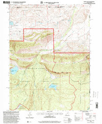
1996 Map of Hoop Lake
USGS Topo · Published 2000About this map
The high-altitude landscape of the Bald Range straddles the border of Wyoming and Utah, where the Wasatch-Cache National Forest and Ashley National Forest converge. This 1996 revision documents a wild region defined by the headwaters of Burnt Fork and Thompson Creek. The geography reveals a legacy of resource management and remote access, featuring a Landing Strip in Gregory Basin and a small Oil Well near several intricate Ditch systems. Significant water infrastructure is visible at Hoop Lake and Beaver Meadow Reservoir, both crucial for local water management. The southern portion of the map transitions into the High Uintas Wilderness, characterized by expansive meadows like Kabell Meadows. The map provides a look at the backcountry infrastructure of the Flaming Gorge Ranger District, including several gaging stations and a Boat Ramp serving the high lakes.
Find a feature on this map
31 named features on this map. Tap any name to fly to it.
Don’t see what you’re looking for? This feature index may not catch every label — zoom into the map to look around manually.
Map Details
Editions of this 1996 Hoop Lake Map
This is the sole edition of this map. No revisions or reprints were ever made.
Other maps of this area

1885 · Ashley
USGS Topo · 1:250,000

1885 · Uinta
USGS Topo · 1:250,000

1905 · Gilbert Peak
USGS Topo · 1:125,000

1906 · Gilbert Peak
USGS Topo · 1:125,000

1906 · Marsh Peak
USGS Topo · 1:125,000

1908 · Marsh Peak
USGS Topo · 1:125,000

1954 · Salt Lake City
USGS Topo · 1:250,000

1954 · Vernal
USGS Topo · 1:250,000

1954 · Ogden
USGS Topo · 1:250,000

1954 · Rock Springs
USGS Topo · 1:250,000