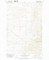
1978 Map of Hoosac
USGS Topo · Published 1979About this map
The settlement of Hoosac sits at the heart of this Fergus County landscape, where the Chicago Milwaukee St Paul and Pacific railroad cuts a diagonal path across the southern terrain. This transportation corridor follows the natural drainage patterns of the high plains, passing through a tunnel as it moves between the watersheds of Pacer Coulee and Sage Creek. The map reflects a rural economy dependent on water and rail, with numerous drainage features like Wolf Creek and Dry Wolf Creek carving the topography.
Find a feature on this map
11 named features on this map. Tap any name to fly to it.
Don’t see what you’re looking for? This feature index may not catch every label — zoom into the map to look around manually.
Map Details
Editions of this 1978 Hoosac Map
This is the sole edition of this map. No revisions or reprints were ever made.
Other maps of this area

1954 · Lewistown
USGS Topo · 1:250,000

1959 · Lewistown
USGS Topo · 1:250,000

1970 · Harwood Bench
USGS Topo · 1:24,000

1970 · Danvers
USGS Topo · 1:24,000
1970 · Big Spring
USGS Topo · 1:24,000
1978 · Soda Spring Coulee
USGS Topo · 1:24,000

1978 · Wild Bill Flat West
USGS Topo · 1:24,000

1978 · Toney Bench
USGS Topo · 1:24,000

1978 · Lewistown
USGS Topo · 1:100,000
1979 · Possum Run Creek
USGS Topo · 1:24,000