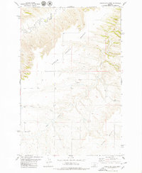
1979 Map of Possum Run Creek
USGS Topo · Published 1979About this map
Arrow Creek carves a deep, winding path through the high plains along the border of Chouteau Co and Fergus Co during the late 1970s. The landscape is defined by its dramatic topographic relief, where the flat upland reaches of Bench and the Alton Bench overlook a complex network of coulees and drainages. The map reveals a sparsely populated agricultural environment where water sources like Spring and Possum Run Creek are central to the terrain's character.
Find a feature on this map
9 named features on this map. Tap any name to fly to it.
Don’t see what you’re looking for? This feature index may not catch every label — zoom into the map to look around manually.
Map Details
Editions of this 1979 Possum Run Creek Map
This is the sole edition of this map. No revisions or reprints were ever made.
Other maps of this area

1890 · Fort Benton
USGS Topo · 1:250,000

1892 · Fort Benton
USGS Topo · 1:250,000

1897 · Fort Benton
USGS Topo · 1:250,000

1954 · Great Falls
USGS Topo · 1:250,000

1954 · Lewistown
USGS Topo · 1:250,000

1957 · Great Falls
USGS Topo · 1:250,000

1959 · Lewistown
USGS Topo · 1:250,000

1964 · Spring Coulee
USGS Topo · 1:24,000

1972 · Square Butte SE
USGS Topo · 1:24,000
1978 · Strouf Island
USGS Topo · 1:24,000