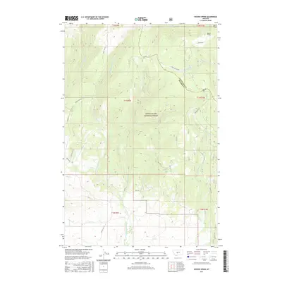
2017 Map of Hoover Spring
USGS Topo · Published 2017About this map
The Lewis & Clark National Forest defines the character of this high-country landscape, where the headwaters of three major drainage systems begin their descent. This 2017 survey reveals a complex hydrological divide along the Judith Basin Co Meagher Co line, where the N Fork Smith River flows westward, the S Fork Judith River moves north, and the N Fork Musselshell River drains to the south.
Find a feature on this map
21 named features on this map. Tap any name to fly to it.
Don’t see what you’re looking for? This feature index may not catch every label — zoom into the map to look around manually.
Map Details
Editions of this 2017 Hoover Spring Map
This is the sole edition of this map. No revisions or reprints were ever made.
Other maps of this area

1886 · Little Belt Mts.
USGS Topo · 1:250,000

1894 · Little Belt Mts.
USGS Topo · 1:250,000

1897 · Little Belt Mts.
USGS Topo · 1:250,000

1898 · Little Belt Mts.
USGS Topo · 1:250,000

1902 · Little Belt Mts.
USGS Topo · 1:250,000

1948 · White Sulphur Springs
USGS Topo · 1:250,000

1958 · White Sulphur Springs
USGS Topo · 1:250,000

1961 · White Sulphur Springs
USGS Topo · 1:250,000
1961 · Kings Hill
USGS Topo · 1:24,000
1961 · Sand Point
USGS Topo · 1:24,000